
In the wake of another season of wildfires across the Western United States, tech giant Google has decided to show the location of wildfires and track their movement.
Google announced on Thursday (August 20) that they will use satellite data to identify locations of wildfire and aid first responders and ensure the safety of communities living near the fires.
In a blog by Google’s Vice-President for Engineering and Crisis Response Yossi Matias, he said the idea to build new features in Google Search and other products started 10 years ago in a Google Office in Haifa, Israel.
Matias said they were looking at a fire near the Google Office and tried searching for them on the web, the team discovered a potentially life-impacting information gap. There was not much information about the fire or a feature that would connect users to an emergency hotline.
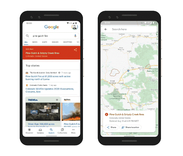
Fast forward ten years later on Thursday, the tech giant announced that they are launching a new wildfire boundary map in Search and Maps SOS alerts in the U.S. to provide deeper insights for areas impacted by an ongoing wildfire.
“In moments like a growing wildfire, knowing exactly where a blaze is underway and how to avoid it is critical,” Matias said.
Satellite data from NOAA to show wildfires in real-time
With the use of satellite data, the wildfire boundary map will allow people to see the approximate size and location of the fire right on their phone or desktop.
When people search for terms like “wildfire in California” they will be given information such as the approximate boundary of the fire, name, and location, as well as news articles and helpful resources from local responders in an SOS alert.
On Google Maps, Matias said people will have access to the same details, including the fire boundary, and receive warnings if they’re approaching an active blaze.
If someone is exploring an area near a wildfire on Google Maps, they will also get an ambient alert that will point them to the latest information.
Satellite data from the National Oceanic and Atmospheric Administration’s GOES constellation of satellites and Google Earth Engine’s data analysis capabilities will show the size of a wildfire in near real-time, with data being refreshed every hour.
A digital polygon or area boundary in Search and Google maps will approximate the wildfire area.
Responders such as firefighters and emergency personnel will gain real-time access to high-quality information right at their fingertips.
Google first piloted the feature last year in the search engine for major California wildfires confirming it was a useful tool for first responders, emergency management personnel, and the community.
Aside from mapping wildfires, Google has also set its sights on providing earthquake information as well as in providing alerts for flood forecasting as it finds ways to use technology in times of crisis.
Read More: Alibaba Q2 Profit Grows 34% Despite Covid-19, Looming US Threats